| Types of Glaciers |
| ||
Glaciers form when snow accumulates on a patch of land over tens to hundreds of years. The snow eventually becomes so thick that it collapses under its own weight and forms dense glacial ice. When enough of the ice is compacted together it succumbs to gravity and begins to flow downhill or spread out across flat lands (Williams and Hall, 1993). There are many different types of glaciers, and not all of them are good indicators of climate change. "Glaciers that do tend to be good climate indicators are small land-based, non-surge type glaciers. They respond directly to both regional temperature and precipitation [snow]," said Dorothy Hall, a hydrospheric scientist at NASA’s Goddard Flight Space Center. She and a team of scientists from around the globe have used satellites over the past 25 years to measure changes in glaciers in Europe, Iceland and Alaska. More than 90 percent of the 33 million cubic kilometers of glacier ice in the world is locked up in the gigantic Greenland and Antarctic ice sheets. Because they are so massive and exist in such frigid latitudes, large-scale changes are very difficult to track and verify, said Hall. In addition to the ice sheets, there are two types of small glaciers that
make for bad climate gauges. "Both surge glaciers and tidewater glaciers
have their own cycles of advance and retreat. These cycles are certainly
related to climate, but we are not exactly sure how," said Hall. Even if
the climate changes in the region, these glaciers would most likely maintain
their distinctive patterns of behavior. |
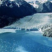 Tidewater glaciers terminate in the ocean, where the boundary can be marked by awesome ice cliffs 200 feet high. When huge blocks of ice break off to form icebergs (a process known as calving) the waves can be large enough to capsize ships. (Photograph by Bill Field, 1971) | ||
| Surge glaciers can sluice down a
valley at rates of up to a few kilometers a day, said Hall.
Once they attain their final destination, they stagnate or gradually retreat for
the next ten-to-fifty years. Tidewater glaciers, on the other hand, advance for
roughly a thousand years before reaching their destination, explained Hall.
When they encounter the sea, they calve and drop icebergs into the water as they
continue to make their way out into the ocean. They then pull back and retreat
over the course of one or two hundred years.
The Muir tidewater glacier in Alaska’s Glacier Bay has been observed for nearly 200 years. Explorers in the mid-1700s recorded observations of Muir at its peak. They noticed that about two hundred years ago it began to recede. Recent measurements show that the glacier has withdrawn more than 90 kilometers (Hall et. al., 1994).
|
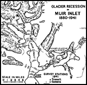 This map, compiled by the glaciologist Bill Field, shows the changes in the glaciers of Muir Inlet, Alaska, from 1880 to 1941. Large map. (Map from the American Geographic Society Collection archived at NSIDC) |
