 |
by Carol Smith April 12, 2000 |
||
|
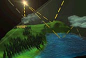
Anyone who is outdoors on a clear day and feels the warmth of the sun can easily understand that the sun radiates energy to the Earth's surface. Understanding the physical processes behind the solar radiation reflecting from Earth's surface on clear days, however, is far more difficult.
|
For more information, visit the Langley Atmospheric Sciences Data Center. |
Scientists have created models to describe solar, or shortwave, radiation at the Earth's surface, but recent studies have yielded conflicting opinions of how accurately the models portray clear days.
"A number of studies have not found any problem with our ability to model clear-sky shortwave radiation in the atmosphere. But, several other studies claim there are problems," said Robert Cess an atmospheric scientist at the State University of New York at Stony Brook. Since many of the studies used short-term data sets, Cess and Xiaodu Jing, a Ph.D. candidate at SUNY, designed an experiment to test the accuracy of clear-sky shortwave radiation models using an extensive data set. They composed a data set of clear-sky days using measurements of solar radiation at the Earth's surface (insolation) and satellite measurements of solar radiation at the top of the atmosphere. Surface insolation measurements were obtained from the Canadian Atmospheric Environment Service. Made at 24 stations in southern Canada, the measurements consist of hourly surface insolation means collected over a four-year period from 1985 to 1988. To focus their study on clear-sky days, Cess and Jing used satellite and surface-based measurements to remove data with clouds or forest fire smoke from nearby boreal forests. "That eliminated about 98 percent of our data, but since we were data-rich, that was not a real problem," Cess said. The satellite measurements of shortwave radiation reflected at the top of the atmosphere were made from the Earth Radiation Budget Satellite (ERBS) as part of the Langley Earth Radiation Budget Experiment (ERBE). The radiometric scanner measurements from ERBS describe the amount of solar radiation reflected back to space from 1985 to 1988. By collocating these satellite data with the surface measurements, the researchers created a clear-sky data set. "This was by far the most comprehensive test of clear-sky shortwave radiation models that has ever been done as far as comparing the data," Cess said. Then, he and Jing then compared the clear-sky data with two atmospheric shortwave radiation models to see if there was any disagreement. One model, the Li et al. algorithm, determines surface insolation by converting satellite top of the atmosphere shortwave radiation measurements to surface insolation. The other model, the National Center for Atmospheric Research Community Climate Model (CCM3), is a stand-alone model that computes surface insolation independently of satellite measurements. To account for atmospheric water vapor variability and atmospheric ozone, Cess and Jing used collocated measurements from the Television Infrared Observation Satellite (TIROS) using the Operational Vertical Sounder (TOVS). They also used aerosol optical depths from NOAA's National Environmental Satellite Data Service (NESDIS) as determined from Advanced Very High Resolution Radiometer (AVHHR) measurements. "We found excellent agreement between the models and the observations," Cess said. For the period studied, 1985 to 1988, they found no inconsistencies between the modeled and the observed clear-sky shortwave radiation measured at the surface. "A big advantage was being able to interface satellite data with surface radiometric data, with satellite water vapor and ozone abundance data," Cess said. A member of NASA's Clouds and the Earth's Radiant Energy System (CERES) team, Cess is looking forward to new combinations of surface measurements and satellite data to further test atmospheric models. "We want to start collocating CERES data with various surface stations much the way we did with the Canadian data to look at various aspects of cloud radio-transfer problems," Cess said. Jing, Xiaodu, and Robert D. Cess. 1998. Comparison of atmospheric clear-sky shortwave radiation models to collocated satellite and surface measurements in Canada. Journal of Geophysical Research. 103, No. D22: 28,817-28,824. |
|