|
A curtain of the atmosphere
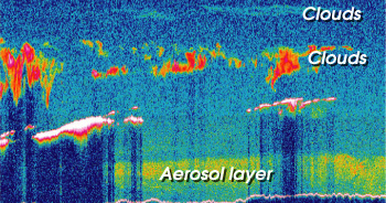
The CALIPSO satellite will provide vertical, curtain-like images of the atmosphere on a global scale using a lidar. The lidar (light detection and ranging) technique is similar to radar in operation, but lidar uses short pulses of laser light instead of radio waves to probe the atmosphere. The lidar data from CALIPSO will allow scientists to determine precisely the altitudes of clouds and aerosol layers and the extent of layer overlap, to identify the composition of clouds and to estimate the abundance and sizes of aerosols. |
CALIPSO Introduction
Related Data | ||
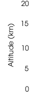 |
The CALIPSO lidar will provide vertical, curtain-like images, such as the one above, of the atmosphere on a global scale. A three-channel imaging infrared radiometer provided by CNES will also be on the CALIPSO satellite. This instrument has a field of view of 64 kilometers by 64 kilometers (about 40 miles by 40 miles) and measures outgoing heat emitted toward space from the atmo-sphere and surface of the Earth. Its design will allow scientists to estimate the size of ice cloud crystals and the amount of heat these clouds absorb and emit. The CALIPSO satellite will also carry a high-resolution digital camera with a field of view of 60 kilometers by 60 kilometers (about 37 miles by 37 miles). The camera provides a large-scale view of the atmosphere surrounding the thin column of air probed by the lidar. Images from the camera will improve the ability of scientists to interpret the lidar observations. For example, the images collected by the camera will allow scientists to determine if the lidar measurements are from a small, isolated cloud or a cloud that is part of a larger air mass. next: The future of CALIPSO
|