|
Aqua Goals The Aqua spacecraft, and more broadly the Earth Observing System (EOS) of which Aqua is a part, continues NASA's commitment to studying the Earth as a global system. Aqua carries six state-of-the-art instruments to observe the Earth's oceans, atmosphere, land, ice and snow covers, and vegetation, providing high measurement accuracy, spatial detail, and temporal frequency. This comprehensive approach, provided by both Aqua and the earlier Terra satellite launched in December 1999, enables scientists to study interactions among the many elements of the Earth system. Aqua, Latin for "water," is named for the large amount of information that the Aqua spacecraft will collect about the Earth's water cycle. In particular, the Aqua data will include information on water vapor and clouds in the atmosphere, precipitation from the atmosphere, soil wetness on the land, glacial ice on the land, sea ice in the oceans, snow cover on both land and sea ice, and surface waters throughout the world's oceans, bays, and lakes. Such information will help scientists to improve the quantification of the global water cycle and to examine such issues as whether or not the cycling of water might be accelerating.
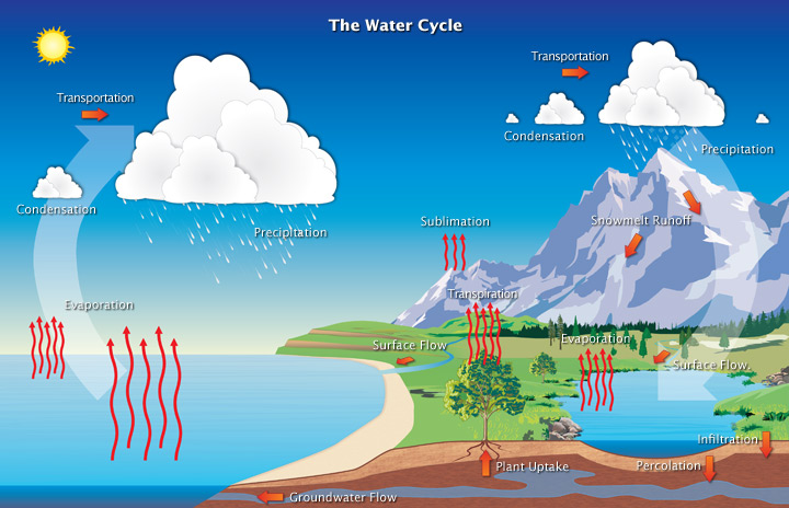
In the hydrologic cycle, individual water molecules travel between the oceans, water vapor in the atmosphere, water, ice, and snow on the land, and underground water. (Image by Hailey King.) In addition to information about the water cycle, Aqua will also provide information on many additional elements of the Earth system. For instance, Aqua will enable studies of the fluxes of radiation from the sun and from the Earth that combine to constitute the Earth's radiation balance. It will also enable studies of small particles in the atmosphere termed "aerosols" and such trace gases in the atmosphere as ozone, carbon monoxide, and methane. The trace gases each have a potential contribution to global warming, whereas the aerosols are more likely to have a cooling effect. Aqua will also provide observations on vegetation cover on the land, phytoplankton and dissolved organic matter in the oceans, and the temperatures of the air, land, and water. All of these measurements will have the potential to contribute to improved understanding of the changes occurring in the global climate and the role of the interactions among the various elements of the climate system. One of the most exciting of the potential practical benefits likely to derive from the Aqua data is improved weather forecasting. Aqua carries a sophisticated sounding system that will allow determination of atmospheric temperatures around the world to an accuracy of 1° Celsius in 1-kilometer-thick layers throughout the troposphere, the lowest portion of the atmosphere. The troposphere extends to an altitude of about 10-15 kilometers, depending on location, and contains most of the global cloud cover. The anticipated 1° Celsius accuracy far exceeds current accuracies from satellite observations and, in conjunction with the moisture profiles also obtainable from the Aqua sounding system, will offer the potential of improved weather forecasting. NASA is working with the U. S. National Oceanic and Atmospheric Administration, the European Centre for Medium-Range Weather Forecasts, and other forecasting centers to facilitate the incorporation of the Aqua data in their weather forecasting efforts. next: Mission Facts |
Aqua Introduction |