Cities, Farms, and Forests: 1920 | |||
By 1920, people were intensively using most of the land in the eastern United States. The age of mechanized agriculture had dawned, and farms were supporting a much higher population base. Although much of the old-growth forest had given way to crops and pastures or villages and cities, forests were re-growing in farm woodlots and previously logged areas, and semi-natural vegetation was beginning to reclaim abandoned farms. This change brought new challenges for Steyaert and Knox. What did the 1920 vegetation look like for each of these land cover types? |
|||
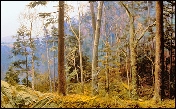 |
1700Undisturbed forests, such as those that grew in 1700, contain trees of varying size and age. Tall trees block sunlight so other plants don't grow well near them. This creates an open forest floor with gaps between the trees. | ||
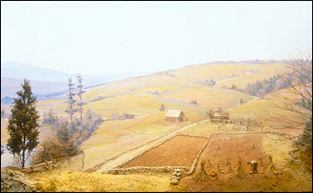 |
1830Farms present an entirely different profile to the atmosphere. Smooth fields offer little resistance to the wind; lighter-colored crops reflect more sunlight; and with fewer leaves than a forest canopy, crops respire less water and soak up less light in photosynthesis. These differences can change local weather. | ||
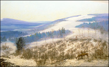 |
1915Trees growing over abandoned fields are packed closely together. The trees all have similar heights, and the land beneath them is still smooth and even after cultivation. The even canopy means that a regrowing forest interacts with the wind differently than an old-growth forest. (Harvard Forest Diorama Photographs © 2002 Fisher Museum, Harvard Forest, Petersham MA. Photography by John Green.) | ||
“We used a wide variety of sources in the recent and historical literature to reconstruct the 1920 land cover conditions,” says Steyaert. “I visited the National Agricultural Library and read the U.S. Department of Agriculture Yearbooks from 1921 through 1925 and other really early books. The libraries at the University of Maryland, NASA Goddard, and the U.S. Geological Survey were also gold mines,” Steyaert recalls. He found regional information on the estimated acreage of regrowing forest and remaining virgin forest with commercially useful timber, as well as many other maps of land use activities based on the 1920 census. Using the census data for both population and farm area along with the other sources of information they resurrected from library archives, the pair developed land-use intensity maps and used them as a basis for mapping the fraction of each county that was lowland or highland agriculture, remnant old growth, and residential and urban areas. Among the new challenges was figuring out how to describe what was happening on farm woodlots and non-farmland that didn’t seem to be either city or old-growth forest. Using census records, regional forest area estimates, and Küchler’s vegetation maps, they split the remaining non-farmland and the farm woodlots into two major components. The first was young, regenerating forest, and the second was “non-restocking land,” where the returning vegetation wasn’t the forest that had grown in the area before. So what was growing in those areas that foresters called non-restocking? “In some cases,” says Steyaert, “the vegetation growing back after logging was like some kind of scrubby oak or pine.” In other locations, such as peat bogs, tree growth is naturally slow. “If the area is blanket peat lands,” says Knox, “and you take off the spruces that actually have had a long enough time to get big enough to be worth cutting, that would be non-restocking. A thirty-year-old spruce might be half a meter tall there.” Even 20 years after logging, the area would be ‘non-restocking’ in terms of commercially useful timber, even though mosses and shrubs would exist. |
|||
 | |||
Grouping the logged, non-restocking forest with degraded farmland identified in the 1920 census, Steyaert and Knox derived a land cover class and biophysical parameters for “degraded land.” “We characterized degraded land as having sparse vegetation, scattered shrubs, scrub trees, and barren land with poor forest regeneration,” says Steyaert. Their analysis showed that by 1920, the original forest had all but disappeared, and virtually no part of the eastern United States remained unchanged at the 20-kilometer scale depicted in the maps. Steyaert and Knox were ready to move to something closer to the present, and this time, they got a break. |
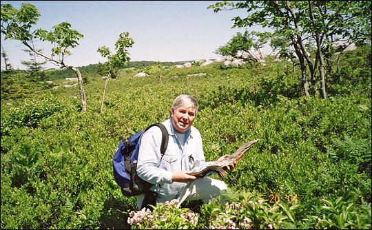
Louis Steyaert kneels in a slowly regrowing mixed forest within the highlands of West Virginia, a landscape that foresters in the 1920s would have called “non-restocking.” The area was logged in the early 1900s, and more than half a century later, only scattered trees have grown back. In some mountainous locations, post-logging fires and soil erosion left the rocky ground unable to nurture tree seedlings. In other cases, regrowth was naturally slow due to climate and soil characteristics. (Photograph © 2004 Lou Steyaert.) | ||
