The Ancient Forest: 1650 | |||
When Steyaert asked him about mapping the forest of 1650—after native land use had declined in the wake of disease brought by early Europeans but before colonial farms took off—Knox already had firm ideas about where to start: the scientific studies of August Wilhelm Küchler. A plant geographer in the mid-1900s, Küchler had spent his career painstakingly mapping the distribution of plants across the United States. Küchler considered soil types and climate to determine what kind of vegetation would have been growing in the United States if the land had been left undisturbed by human activities. “Other people had used Küchler data,” says Knox, “but my opinion is that there is a terminology barrier.” Modelers took Küchler’s “evergreen forest” category, for example, and applied the same biophysical values to all evergreen forests, whether they were in the White Mountains of New Hampshire, where the average tree height was 10-20 meters, or the Deep South, where a 50-year-old loblolly pine can reach 30 meters. “Even if you treat all conifer needles the same,” explains Knox, “just the architecture of the forest would change how it interacts with the atmosphere.” |
|||
 |
|||
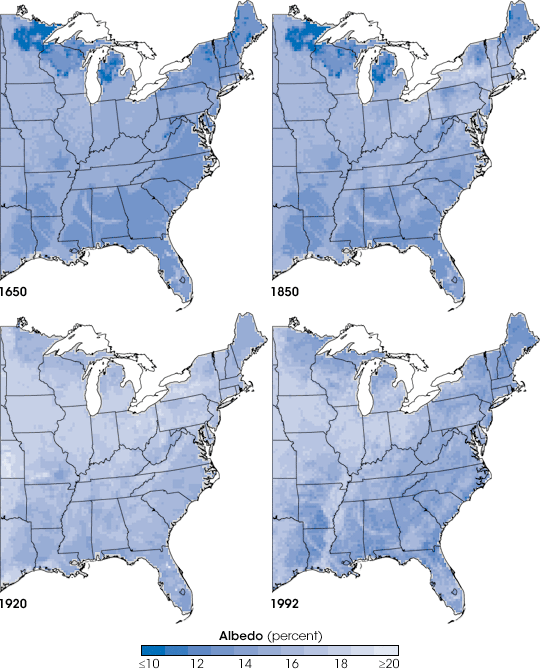
What modelers had previously overlooked was the manual that went along with Küchler’s potential natural vegetation map. The manual plus Küchler’s related scientific publications detail what kinds of plants would grow in each specific vegetation type, or land cover class, with a description of the land-cover characteristics. Küchler describes the oak-pine forest of New England, for example, as a “medium tall forest of broadleaf deciduous and needle leaf evergreen trees. In places the forest is low, even shrubby.” Knox realized that these descriptions—dense, sparse, scattered, medium tall, shrubby—contained a wealth of information that could be used to estimate biophysical parameters. As the first step, Knox translated Küchler’s vegetation classes into a set of consistent land cover classes that represented the foundation for the 1650 land cover and a suitable framework for subsequent land cover changes. For his part, Steyaert realized that while Küchler’s descriptions were excellent, they were based on observations made between the 1930s and the 1960s, after many changes to the native landscape had already taken place. Using older descriptions gleaned from hours in the library, Steyaert identified limitations in the Küchler’s vegetation classes and defined additional land cover classes to account for some of the well-documented land use changes after 1650. The next task, then, was to translate Küchler’s modified land cover classes into estimated biophysical parameters, the “real numbers” that determined the interactions between the land and the atmosphere. Modelers need to know, for example, exactly how much sunlight the land reflects compared to how much it absorbs, a value called albedo. Light-colored land cover, such as snow or pale sand, has a high albedo, or reflects most of the sunlight that hits it. A dark pine forest, on the other hand, absorbs more of the Sun’s energy and so has a low albedo. Steyaert and Knox compared Küchler’s vegetation types and current vegetation with modern measurements of albedo recorded both in field studies and by satellite instruments such as NASA’s Moderate Resolution Imaging Spectroradiometer (MODIS). Field measurements might indicate that a low, shrubby forest that contained both evergreen and broadleaf deciduous trees like oak had an albedo of 0.13, and so, Steyaert and Knox estimated that those places that Küchler designated as being covered by low, shrubby mixed forests had an albedo of 0.13. |
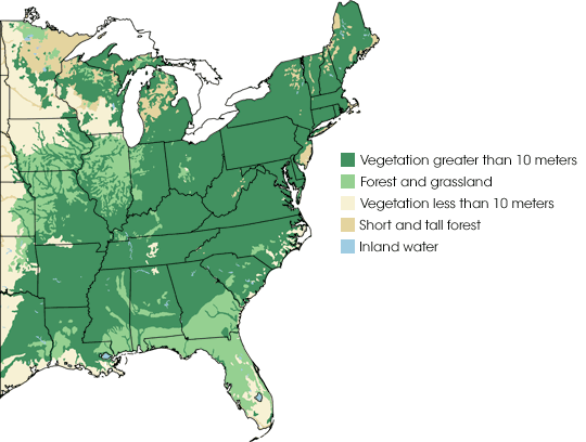
Regional climate modelers who want to understand how the 1650 landscape interacted with the climate need to describe vegetation in terms of characteristics that influence the atmosphere. One such characteristic is vegetation height, shown here. A bird soaring over the Eastern United States in the 1650s would encounter mostly forest greater than 10 meters (about 30 feet) tall. Flying west over the Mississippi River, the bird would dip down to less than 10 meters as it skimmed over the top of prairie grassland and low trees. Along segments of the coast and the north were forests with patches of tall trees and patches of shorter trees. In the south and along the boundary between forest and prairie, mixed patches of grassland and forest grew. (Map by Jesse Allen and Robert Simmon, based on data from Steyaert and Knox.) | ||
 | |||
Over the next three years, Knox and Steyaert would come up with biophysical parameters for all the land cover classes they would need to classify U.S. vegetation during each of the four time periods they planned to map. They estimated values for vegetation characteristics such as leaf area, the ratio between the number of leaves that cover an area and the ground area; deciduousness, what proportion of the leaves disappear during cold winter months; canopy height, the height of the tallest layer of plants in a forest or grassland; and surface roughness, the amount of turbulence the plants create as wind blows around them. But how had those parameters changed as the United States was settled? To determine what had changed, Steyaert and Knox turned to the first quantitative record of land cover change in the United States: the 1850 census. |
Albedo is the percent of sunlight reflected by Earth’s surfaces and atmosphere. Surfaces with high albedo reflect more light and absorb less energy than surfaces with low albedo. In 1650, dark-colored forests covered much of the East. By 1920, nearly all the forest had been replaced with lighter-colored vegetation like crops. As the forest regrew in patches during the latter half of the twentieth century, the land began to absorb more energy and reflect less light. Each of these transitions may have influenced the weather. (Maps by Jesse Allen and Robert Simmon, based on data from Steyaert and Knox.) | ||
